![]()

Maritime Archaeology Institute
International Maritime Archaeology Field School 2025 in Porkkala, Finland
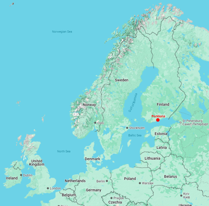
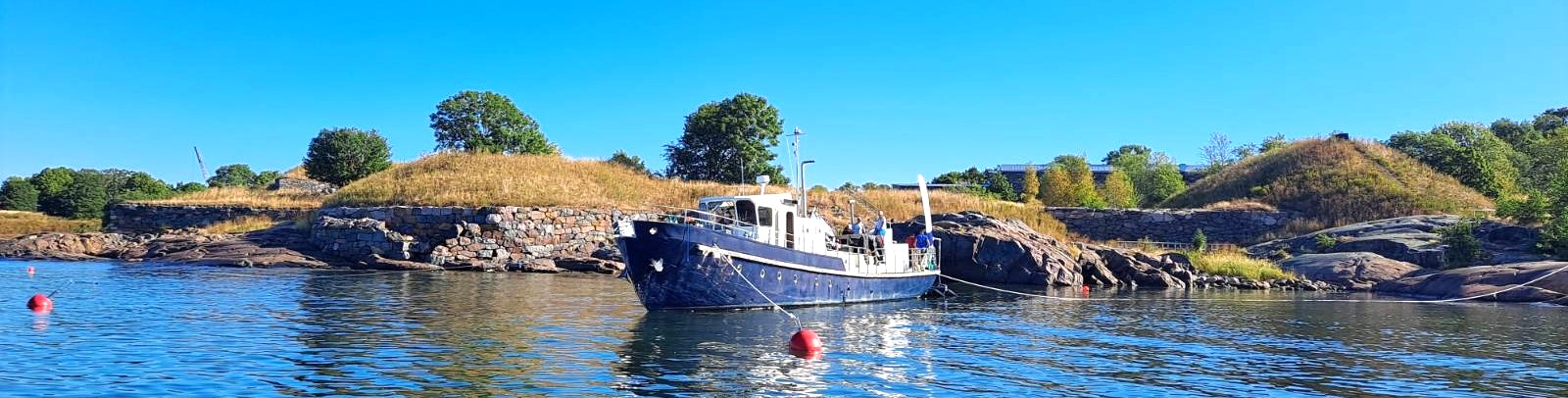
This web page is the "working repository" of the Maritime Archaeology Field School which took place from the 1st untill the 19th of September 2025 in Porkkala, Finland. The Field School was facilitated by the MAS Maritime Archaeological Insitute (MAI) for the Universities of East Carolina (ECU) and Helsinki (UH) also in close co-operation with the Finnish Heritage Agency (FHA). The Field School's base-camp was in the "Porkkalan Leirikeskus" i.e. Camp Porkkala and the official language was English. When out to the sea, MAS flagship DSV Stella was our home-base for the day. However, on most days there was also a shore team working on land sites.
The Field School did teach and research the holistic maritime archaeological landscape of Porkkala peninsula from underwater, ashore and on land. Primary research questions included previously unresearched shipwrecks, as well as the potential locations(s) of the Porkkala port and village during late iron age and medieval times. The existing archaeological inventory of the area is mostly superficial. Hence the maritime archaeological assessment and interpretation of previously identified sites was in an important role too.Weekend visits to Estonia, Suomenlinna and other signifficant maritime cultural historical sites were included in the program. All field work was done on actual sites "learning by doing" under the supervision of ECU and UH academics.
AI-translated summary can be found here.
Public visitor event was organized on-site on the 11th of September 2025 at 14:00. Further details and registration here.
Contact person for all external inquiries is Markku Luoto, contact details below. Additional infomation about MAS in English via our annual reports 2023 and 2024.
 |
 |
 |
 |
 |
 |
| Lynn Harris Professor tel.+01-252-328-1967 |
David Stewart Associate Professor tel.+01-252-328-1124 |
Eric Oakley Assistant Professor tel.+01-252-328-1031 |
Mark Keusenkothen Director of Diving Safety tel.+01-252- |
Vesa Saarinen Captain of DSV Stella tel.+358-40-550-8684 |
Markku Luoto Chairman of MAS tel.+358-40-844-9511 |
 |
|
|
|
|
|
Links to on-line resources
- Feedback questionaire for the 2025 camp: https://mas.fi/fi/porkkala-2025-feedback
- MAS Onedrive for up/downloading pictures & other materials: https://suomenmas-my.sharepoint.com/:f:/g/personal/si_suomenmas_onmicrosoft_com/Eq8qGVUiuYpPpn1QjI3495AB8qvg1b2_Eu0zRLHN-FOK0Q?e=8Ap02J
- MAS Onedrive for pics&videos form the 30th anniversary: https://suomenmas-my.sharepoint.com/:f:/g/personal/si_suomenmas_onmicrosoft_com/EhropFmQITpPmUdMfzuZx14BjVVUXxR8Cwp0Kw_AeHoifQ?e=4YZlwZ
- MAS 30 Years seminar recordings: https://www.mas.fi/fi/ajankohtaista/tapahtumat/mas-30-years-seminar
- The dived wrecksites
- Boatwreck "Dragesviken"
- Shipwreck "Alku"
- Wrecksite "Cannon side or tykkikylki"
- Wrecksite "Remmarudden - Grand Cannon"
- 3D-model (gun with carriage): https://sketchfab.com/3d-models/remmarudden-lavettitykki-7d314730d8da4bb9bf5168007076fffd
- 3D-model (gun without carriage): https://sketchfab.com/3d-models/remmarudden-iso-tykki-e851ae0f57f246969ad53ec5dc00f4be
- FHA homepage: https://www.kyppi.fi/palveluikkuna/mjreki/read/asp/r_kohde_det.aspx?KOHDE_ID=1191
- Shipwreck "Pampskatan-1"
- Shipwreck "Stora Hamnholmen"
- 3D-model: TBD
- FHA homepage: https://www.kyppi.fi/palveluikkuna/mjreki/read/asp/r_kohde_det.aspx?KOHDE_ID=1250
- Boatwreck "new find"
- No other info except the sidescan sonar picture down below.
- All 3D-models of wrecksites recorded by MAS at Sketchfab: https://sketchfab.com/mas-fi/models
- All source materials (e.g. videos) and original high resolution 3D-models for the models at Sketchfab: https://masdownload.mikrojebe.fi/kohteet/ (User ID and Password are both "hylky")
- All shipwrecks and other protected arcahelogical sites in FHA's registry: https://www-kyppi-fi.translate.goog/palveluikkuna/mjreki/read/asp/r_eihakuehtoa.aspx?_x_tr_sl=fi&_x_tr_tl=en&_x_tr_hl=en&_x_tr_pto=wapp (Google translate shows various warnings but just click allright to them and retry - it will eventually work all the way)
- All shipwrecks and rumoured ones in Finland - often some links to stories too: https://hylyt-net.translate.goog/?_x_tr_sl=fi&_x_tr_tl=en&_x_tr_hl=en&_x_tr_pto=wapp
- Lots of "lost at sea" information fragments based on sea area and name of vessel: https://haverit-net.translate.goog/?_x_tr_sl=fi&_x_tr_tl=en&_x_tr_hl=en&_x_tr_pto=wapp
- A 30 page illustrated glossary to ship building terms: https://www.brown.edu/Departments/Joukowsky_Institute/courses/maritimearchaeology11/files/17920584.pdf
- A research homepage of the "Falken" shipwreck with Niklas Eriksson's story of "virtual diving": https://www.mas.fi/en/julkaisut/hylkykohteet-merialue/hearth-wreck-uunihylky-kirkkonummi-mvid1183
- Markku's "entry level" camera rig: 2 X Sony FDR-x1000V, one set for 4k/25fps and another FHD/50fps, both at 120 degree filming angle. Lights (2x) are "noname" Chinese from Aliexpress claiming 15k lumens.
- Topi's "good value" camera rig: Camera: Panasonic gh 5s, Optics: Panasonic 8-18 leica, Underwater housing: Nauticam gh5, Lights: 2xBigblue VL8300p.
- Map of cold war remains in Porkkala: https://www.lynx.fi/parenteesi-suunnistuskartalle/
- ...
Program
| Monday | Tuesday | Wednesday | Thursday | Friday | Saturday | Sunday |
|---|---|---|---|---|---|---|
|
1. Camp Porkkala - Arrival & baggage |
2. Camp Porkkala - e.g. Dragesviken boat wreck - Inspecting land sites |
3. Camp Porkkala - Alku wreck by Stella - Precision inventory Pampskatan |
4. Camp Porkkala - Cannons dump site by Stella - Precision inventory Pampskatan |
5. Porkkala => Estonia / Tallinn - Breakfast and move-out - Ship Helsinki - Tallinn 15:15 (14:15)
|
6. Estonia / Tallinn |
7. Estonia / Tallinn => Porkkala - Hanse Koggs at P. Margareeta - Ship Tallinn-Helsinki 18:30 (17:30) |
|
8. Camp Porkkala - Alku wreck by Stella - Precision inventory Pampskatan |
9. Camp Porkkala - Pampskatan-1 wreck by Stella - Precision inventory Pampskatan |
10. Camp Porkkala - Pampskatan-1 wreck by Stella - Inventory of "village area" |
11. Camp Porkkala Media & Public Day - Pampskatan-1 wreck by Stella - Inventory of "village area"
|
12. Camp Porkkala => Suomenlinna - Coastal navigation to Suomenlinna |
13. Suomenlinna - Island survey - MAS 30 years seminar(?) etc. - Student stuff with UH students |
14. Suomenlinna/Porkkala - Tall ship sailing? - Navigation challenge - Stella back to Porkkala |
|
15. Camp Porkkala - Cancelled by weather - Inventory of "village area" |
16. Camp Porkkala - Dragesviken boat-2 by Stella - Inventory Engelsmans Batterigrundet |
17. Camp Porkkala - Stora Hanmholmen wreck by Stella - Cleaning out Pampskatan |
18. Camp Porkkala - Dokumentatation and packing - Cleaning out "village area" |
19. Camp Porkkala => Airport - Transportation to the airport
|
20. Arrival in U.S.
|
Potential Wreck and Land sites for Research and Field School
All potential wrecksites can be downloaded as PDF here: ![]() appendix_english_liite-1_wrecks_and_water-areas-en.pdf
appendix_english_liite-1_wrecks_and_water-areas-en.pdf
All potential land sites can be downloaded as PDF here: ![]() liite-2_maa-_tai_kosteikkoalueet_v2b.pdf
liite-2_maa-_tai_kosteikkoalueet_v2b.pdf
"House Wrecks" of the camp site bay "Dragesviken": Two (rowing?) boats of which the southern one (Dragesviken-3) is presumably more recent, thus non protected and can be freely used for (intrusive) training. Maximum depth about 20ft and no fishing nets or other evident threats have been noted on the wrecks. These wrecksites are perfect for testing one's equipment and getting acquinted with local conditions (weighting, temperature, visibility).
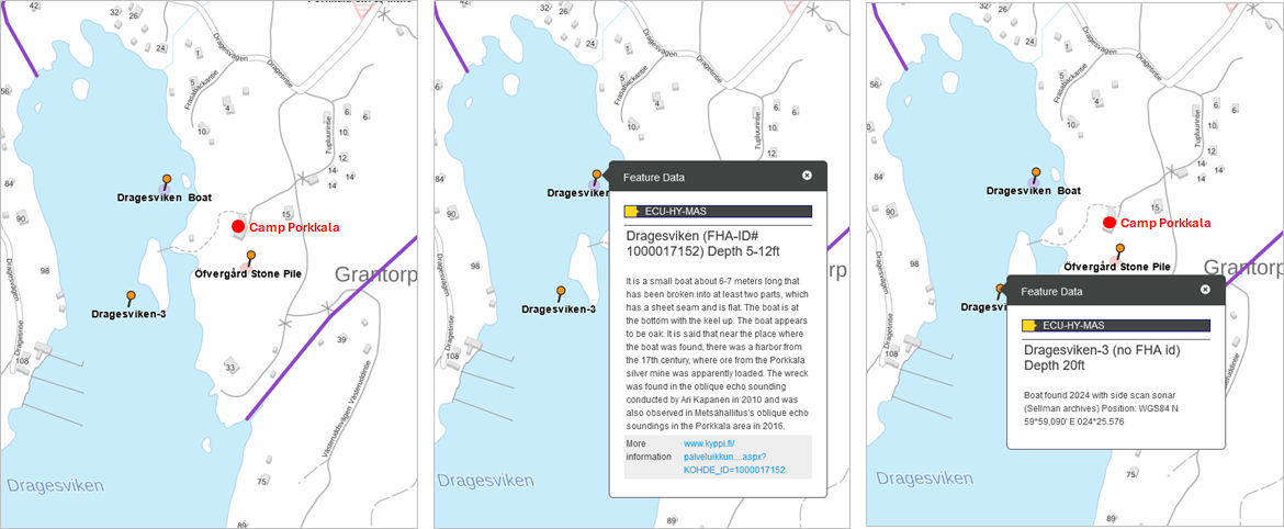
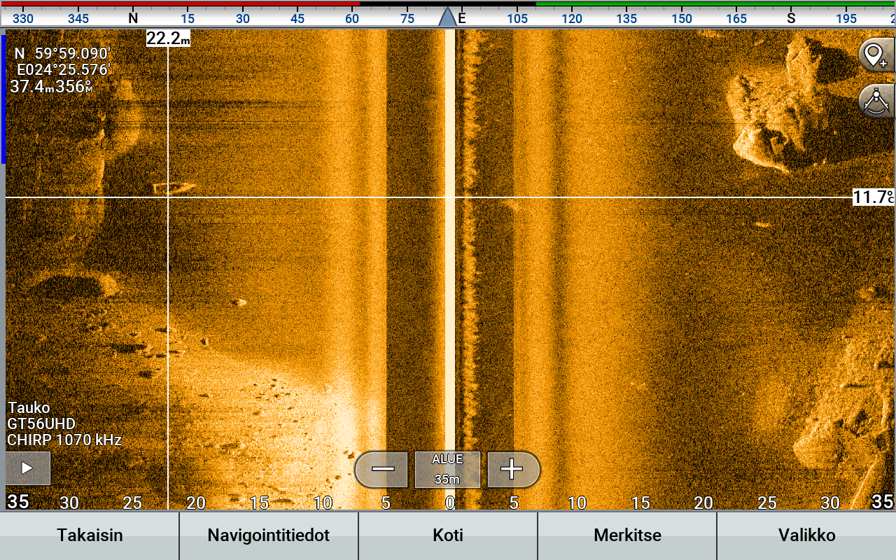 The Dragesviken-3 boatwreck on the croshairs of a side scan sonar screen. The survey vessel has travelled form north to south and passed the boatwreck from the west side of it, hence the boatwreck appears on the left side of the screen and survey vessel's keel line.
The straight cut stern of the boat hints towards a 20th century boat.
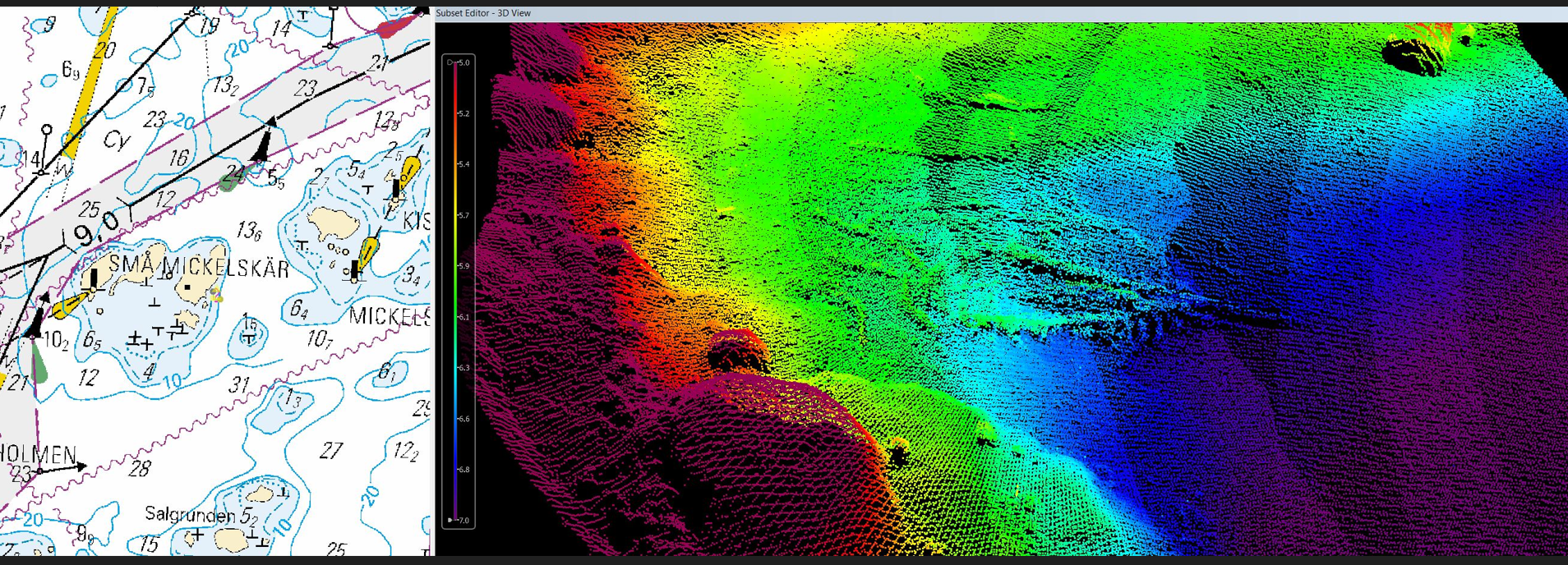
Små Mickelskären Shipwreck, a new anomaly report from the National Water Way Authority, which seems to show a new wrecksite on the South-Eastern side of the Små Mickelskären islands. The wrecksite is in between 20 to 30ft of water and well protected from most winds due to the adjoining archipelago. Judging by the multi beam sonar pictures, there are no cavities or loose nests etc. evident threats. This is a very typical "real thing" case, where the wrecksite needs to be repositioned, inspected, furnished with buoys, recorded "in situ" for photogrammetry with cross check measurements, then sampled for dating and if deemed "interesting" also test excavated (test pits and trenches).
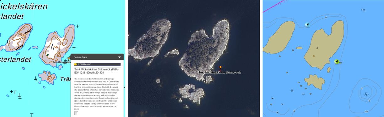
multibeam sonar pictures and the water way authority's anomaly report:

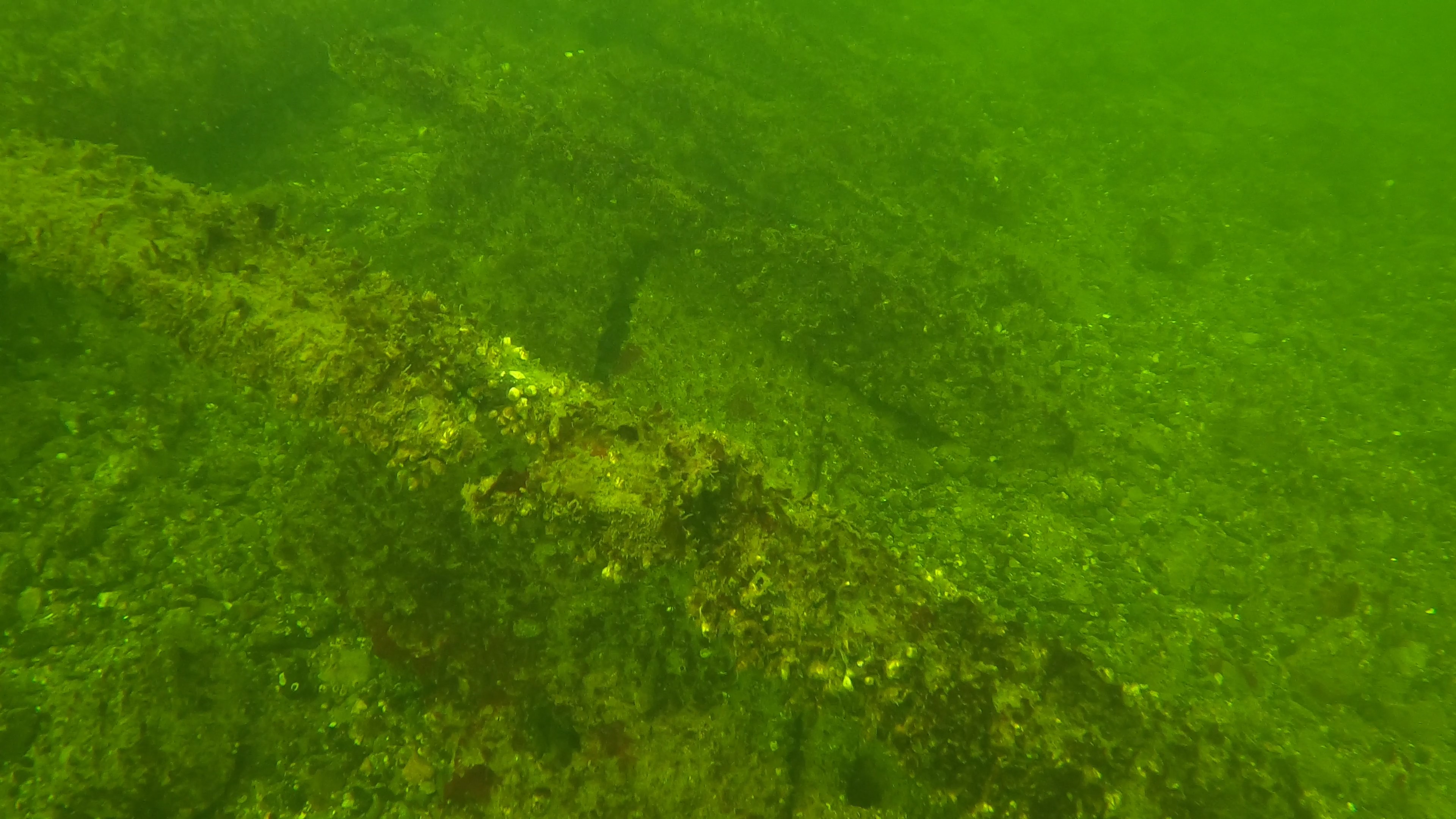
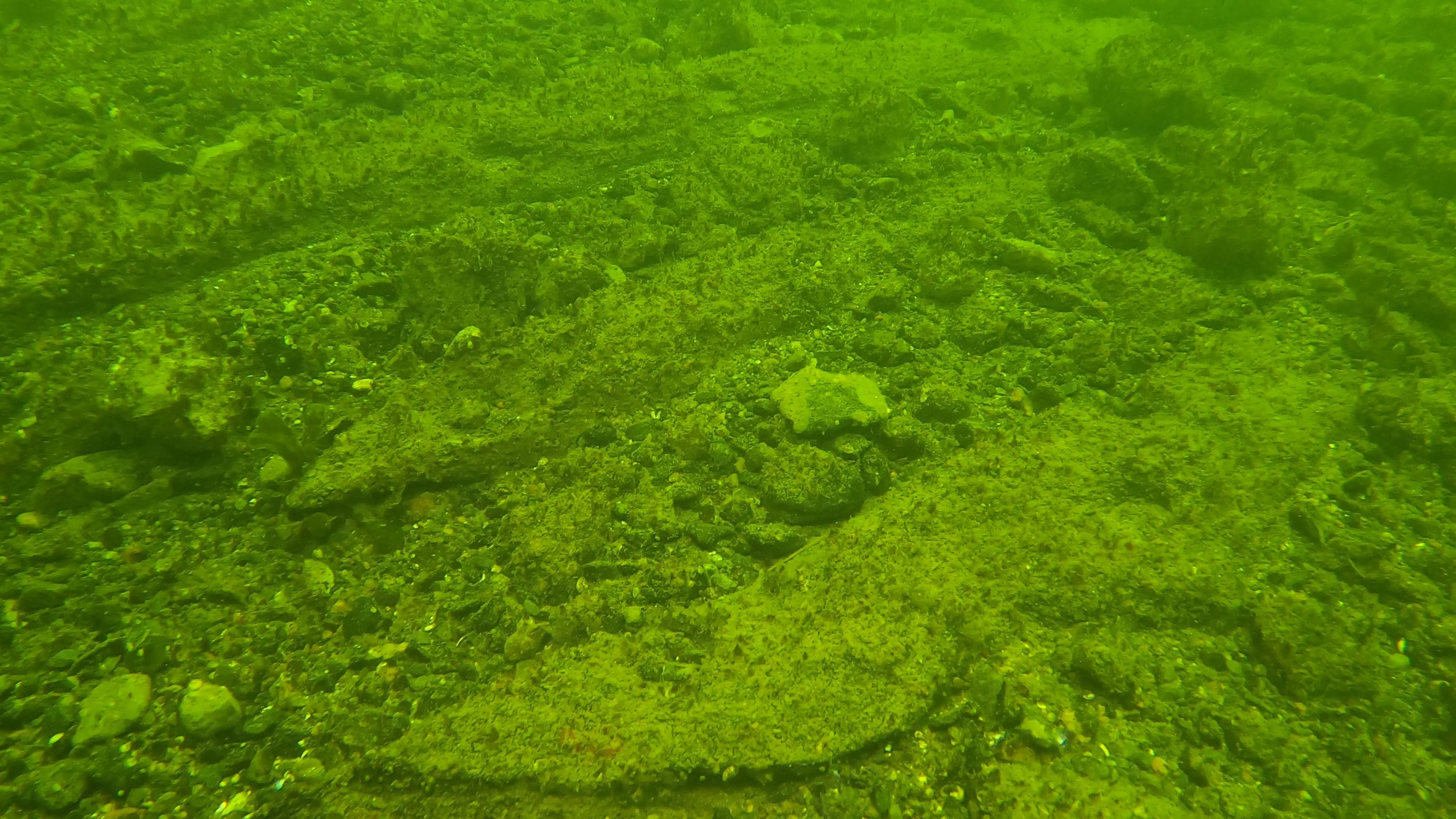
Engelskobben-1 wrecksite, a new diver inventory report and some pictures of the wrecksite. There ae contradicting observations of the site's location, but they both agree that the maximum depth is about 20ft. This wrecksite is quite protected from all but South-Western winds, which unfortunately are the most common ones. As can be observed from the pictures, the wrecksite is quite flat i.e. without cavities and seemingly no loose fishing nets or other hazards. This is also a very typical "real thing" case, where the wrecksite needs to be repositioned, inventoried from a larger area, furnished with buoys, recorded "in situ" for photogrammetry with cross check measurements, then sampled for dating and if deemed "interesting" also test excavated (test pits and trenches). The fact that the wreck is deeply burried in a fairly hard bottom may hint towards an older wrecksite - possibly a middleaged one.


- Report: ![]() etsinasukellus_300922_hannu_rokka-1.pdf
etsinasukellus_300922_hannu_rokka-1.pdf
- Comments: "There are a few bigger pieces between Engelskobben and Söderskär too"
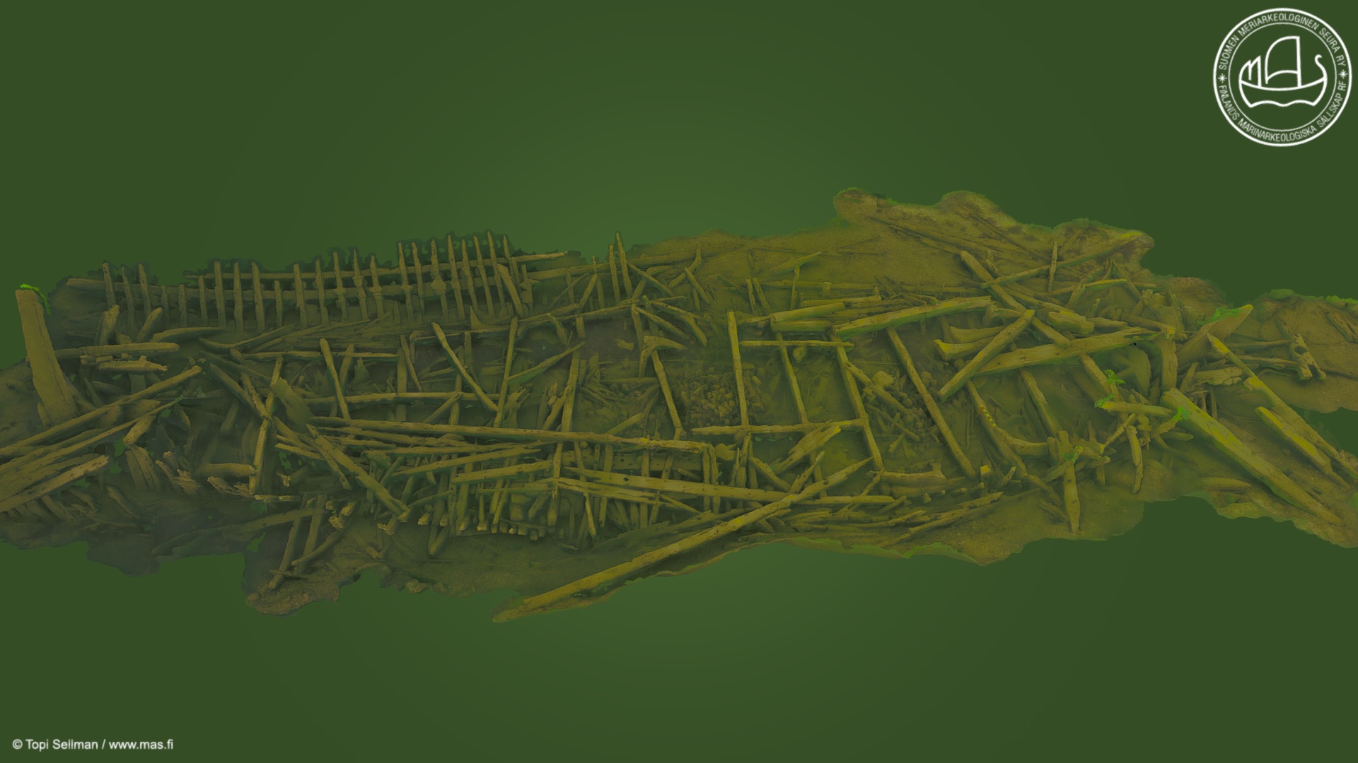
Stora Hamnholmen Shipwreck, a "serious" rumour about a fairly large, up to 30m. long and quite intact wooden shipwreck in about 20ft. of water. The facts that make the rumour serious are that it's listed in the FHA's registry, reported by a commercial diver, who was also the first to own a private side scan sonar, plus there are remarks that the wreck has been dived in the 80's. This wrecksite is a non typical case in a sence that usually the fairly intact wrecks are better known and dived on. Repositioning the wrecksite may require some additional side scanning, but if the wreck is indeed that big, it should be easy. After repositioning, the wrecksite should be surveyed for potential dive hazards before the research activities. A large intact shipwreck poses a challenge for the photogrammetric recording and even more so for the traditional techniques. Hence, this being a more challenging site, it's likely to be surveyed on the latter part of the field school. 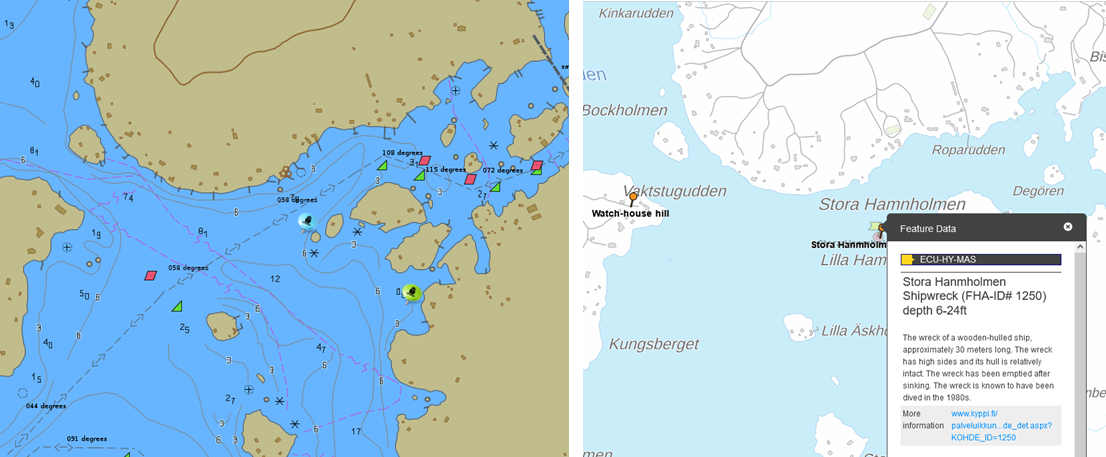
Other Potential Wrecksites to Visit
There are a number of other suitable wrecksites in the area (max 30ft depth) which could be visited for studing the various typologies of the Baltic Sea wrecks. Some of these are already surveyed and 3D-modeled. The models can be accessed by clickin the images below -or- the images can be enlarged by right cliking them and choosing "open image in new tab". Exhaustive list of all potential sites as PDF ![]() here.
here.
|
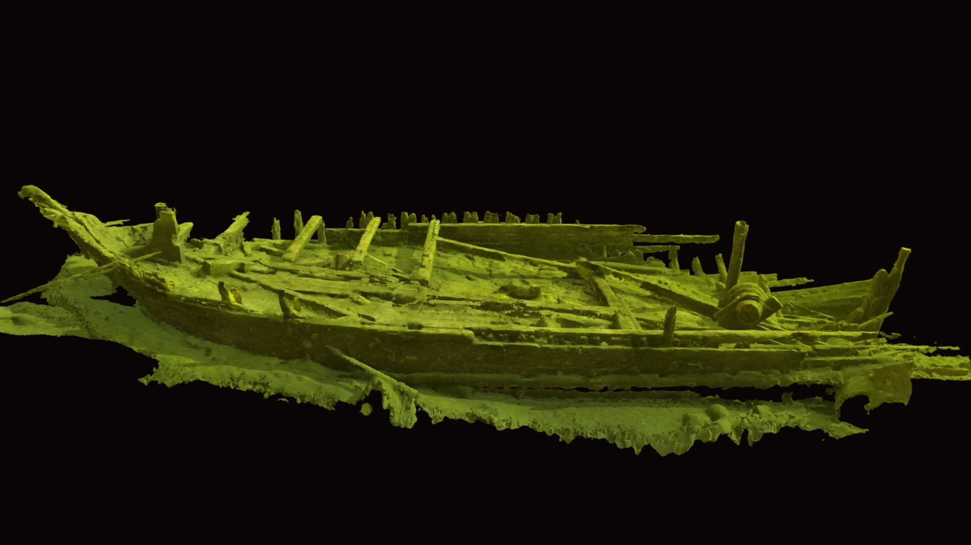
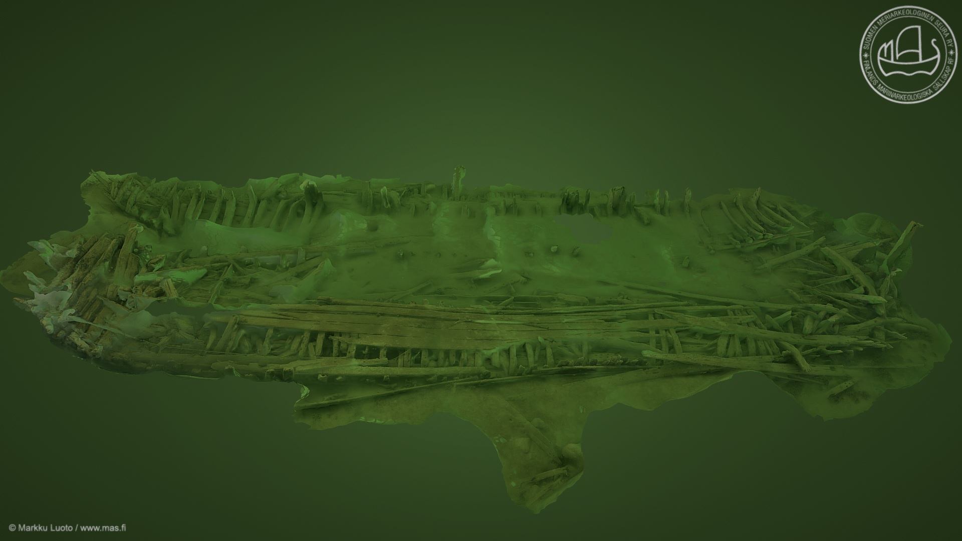
"Varmbådan" shipwreck, 20-30ft depth. An early 17th century Swedish Manowar with a large hearth. |
"Alku" wreksite, 15 to 30ft depth. A mid 19th century coastal freighter full of limestone. |
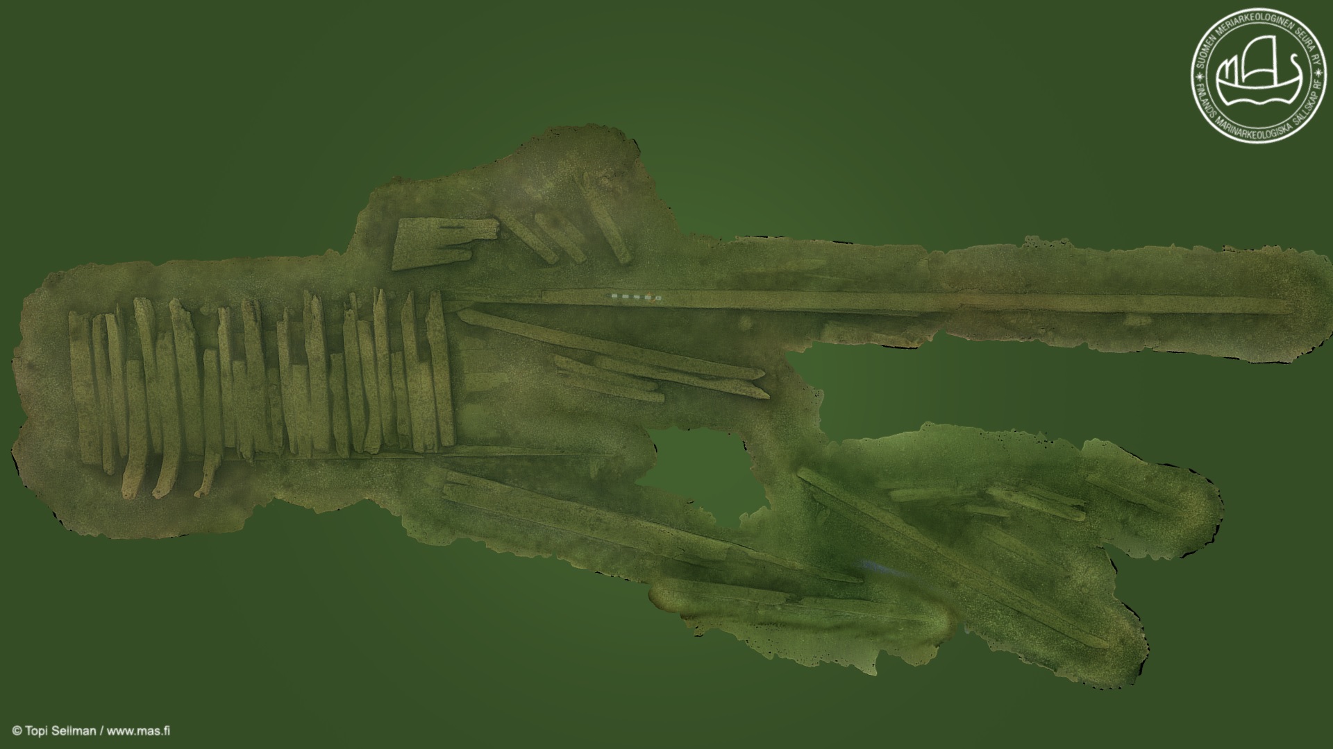
"Pampskatan" shipwreck, 3 to 23ft depth. Presumably an 18th century Manowar with several decks. |
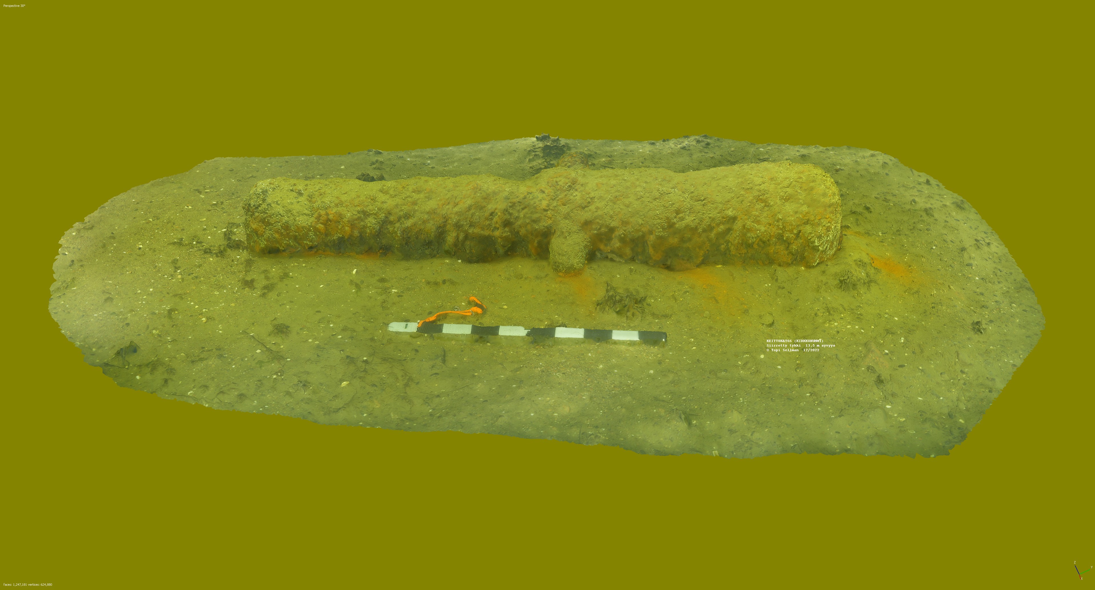
"Putkinotko" Cannon dump area, 10-30ft depth. Large finds area, where 4-6 cannons and cannonballs + twinshots are yet missing. |
|
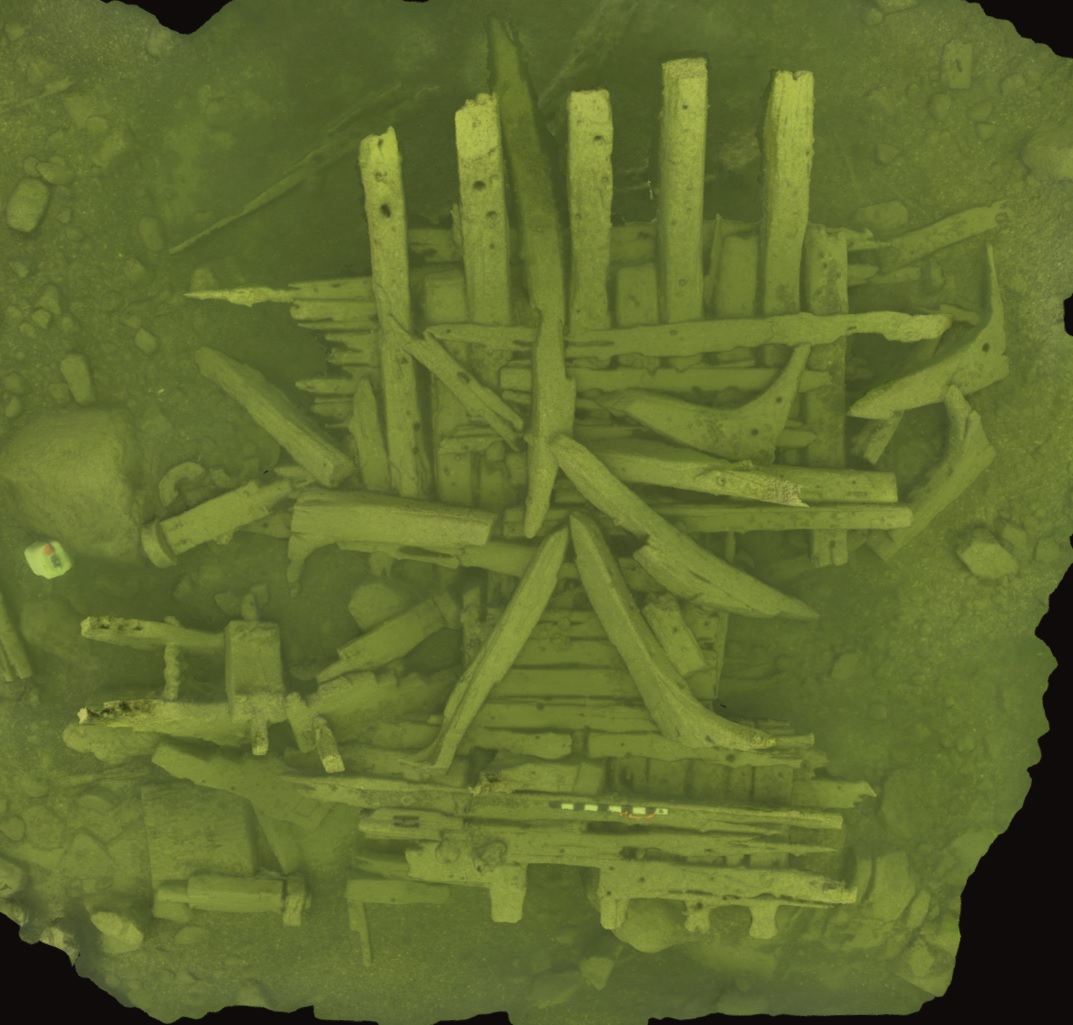
"Tykkikylki" wrecksite, 25 to 33ft depth. A large piece of Manowar hull with one cannon and two carriages. |
"Truttkobbarna" wrecksite, 23 to 30ft depth. A large fragment of a carvel built ship yet to be dated.
|
"Ormholmarna" cannons & "Kyrkogårdsö" shipwreck, 20 to 30ft Depth. Unsurveyed wrecksite in FHA registry (generic pic.) |
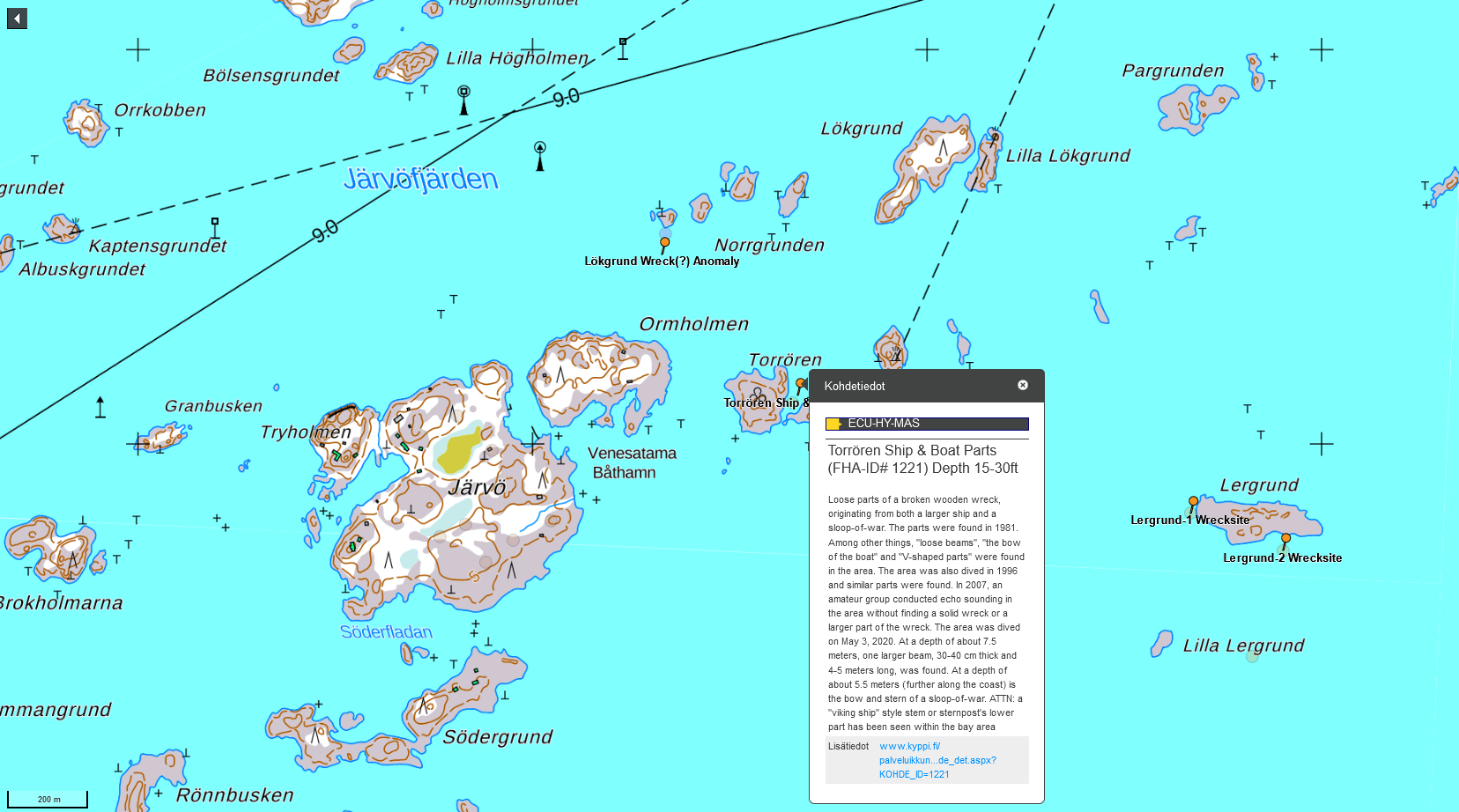
"Torrören" Viking boat parts, 10 to 25ft depth. Once sited "Viking boat like" stem or sternpost part ("cutwater") to be found a.a. |
Potential Sites Ashore for Research and Field School
Lillanskogdraget, a very likely "boat drag" (place name + topology) which due to ground upthrust has likely been an important pass though during the Iron Age. Both shores should be surveyed for burried items (sonding) and for artefacts (metal detector). On land, metal detecting is probably the only viable way of surveying, since organic items are not likely to survive the acidous soil. 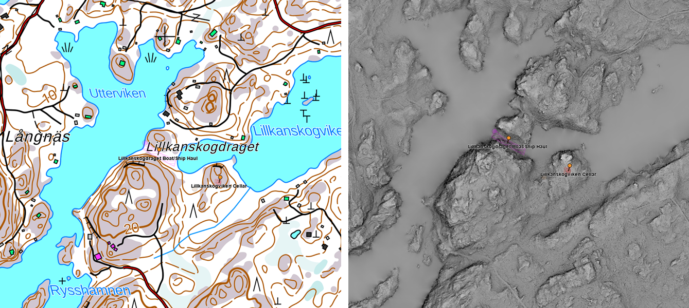
Porkkalasundet, a medieval or possibly even iron age canal (NE purple line), which is said to have split the "old village" of which the earliest record is allegedly from 1255AD. The NE end of the canal is marshland and some preliminary surveys have yielded "bieps" on its SE "shore". The marsh area is extremely interesting as the "village harbour" must have been somewhere there and as the mars preserves organic material magnicent. Test pits or even test ditch may be excavated as there are no protected areas. 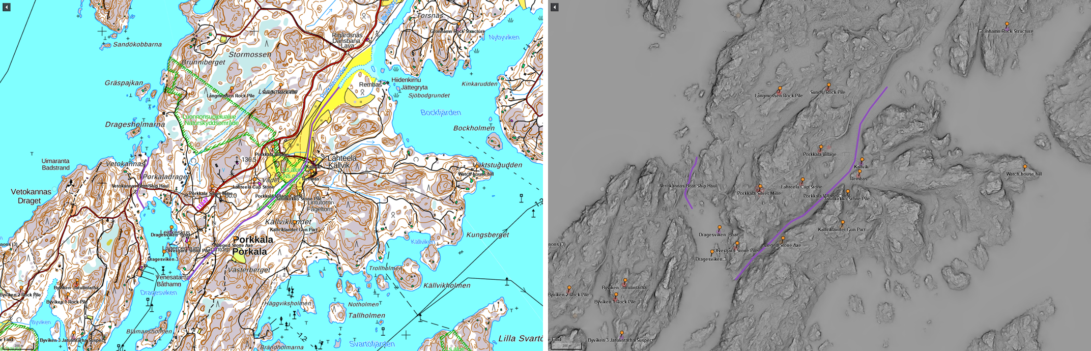
Vetokannas, yet another almost certain "boat drag" (place name + topology + records), which has been used up to the 19th century. Again the after effects of teh ice age could have made this a sailable pass though up 'till late midle ages. Both shores should be surveyed for burried items (sonding) and for artefacts (metal detector). On land, metal detecting is probably the only viable way of surveying, since organic items are not likely to survive the acidous soil. 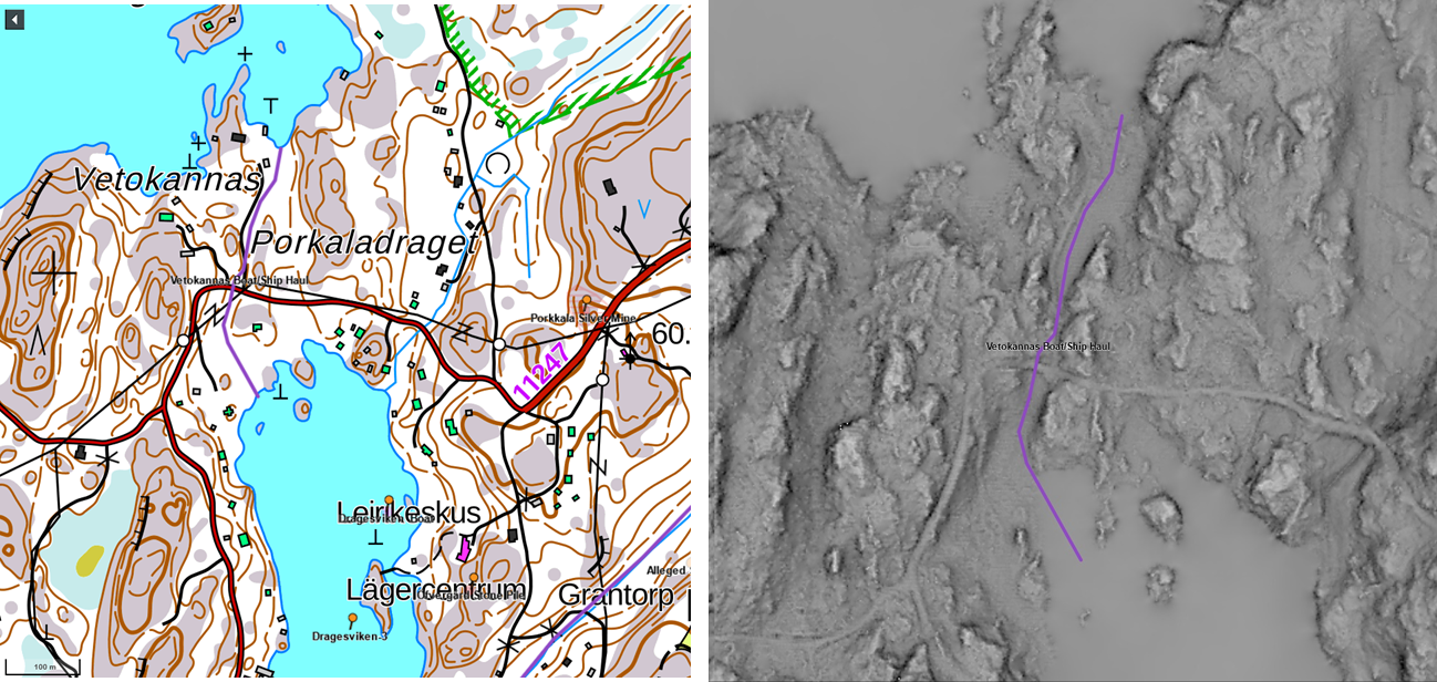
Potential Sites on Land for Research and Field School
Jätinkirkko, a previously uninventoried, very large rock pile in a perfect "manor" position - uphill from the canal and medieval village. A "level laser" and spray/chalck to mark 1m, 2m and even 3m sea levels on the "shoreline" may become handy determining the topographic features of the site. <Kristin will fill in a short description of tasks>. Test pits or even test ditch may be excavated, as this is not a protected site and may yet prove to be modern (e.g. Soviet era). 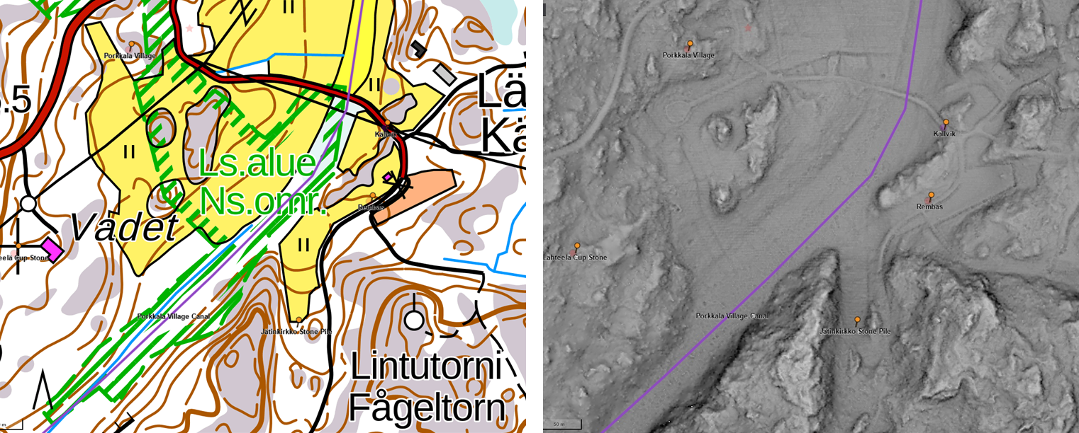
Rock Piles & "Jatulintarhas", there are at least a dozen of inventoried rock piles, some protected and some not, but none ever surveyed. They have alvays been assessed only from the land perspective => might they be sailing route markers etc. sign posts or are they really graves? They should be surveyed and the most likely to be worth excavation should be chosen for next season to be excavated. Jatulintarhas are also worth reassessment and documentation (drone?). 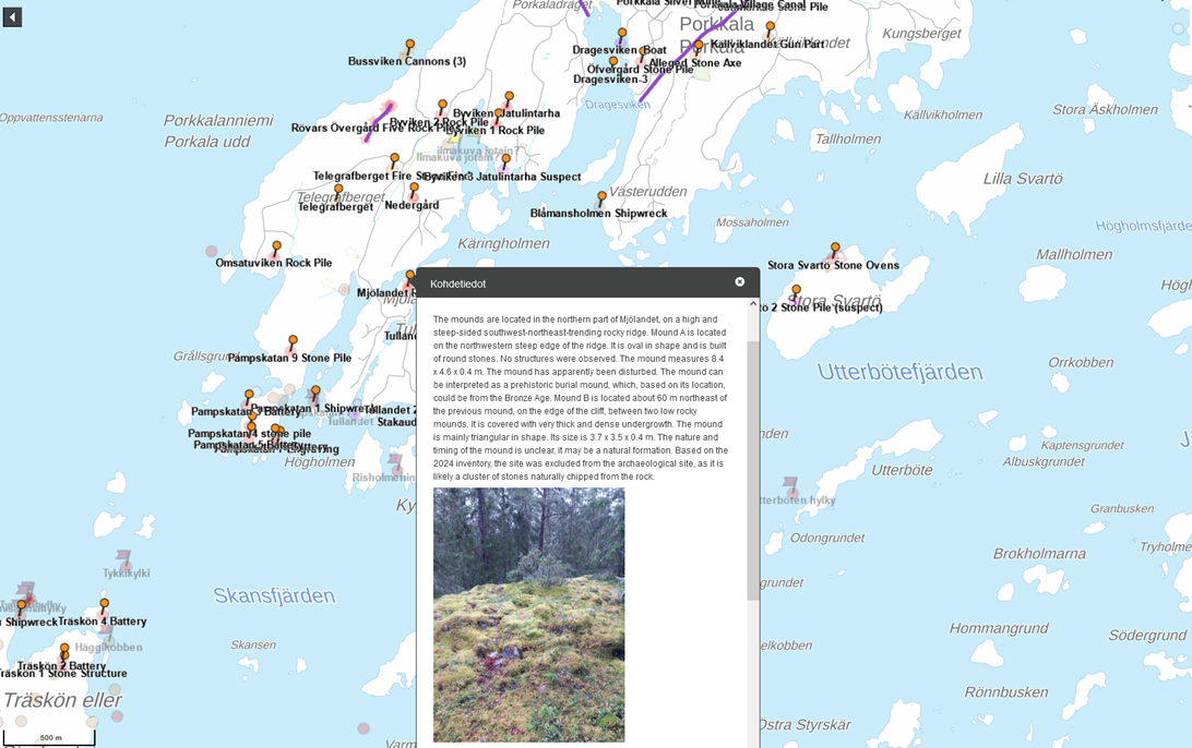
Medieval Harbour and Village. Where was the late iron age or medieval international port of Porkkala? We have some hints about the village in early 16th century + the folklore but no description of the sailing ship port(s) where the Knars and Kogs traded or waited for favourable winds. Has it been on the peninsula -or- was it e.g. on Träskön island where there was also a fresh water lake? The village boundaries may be easier to define around the canal area,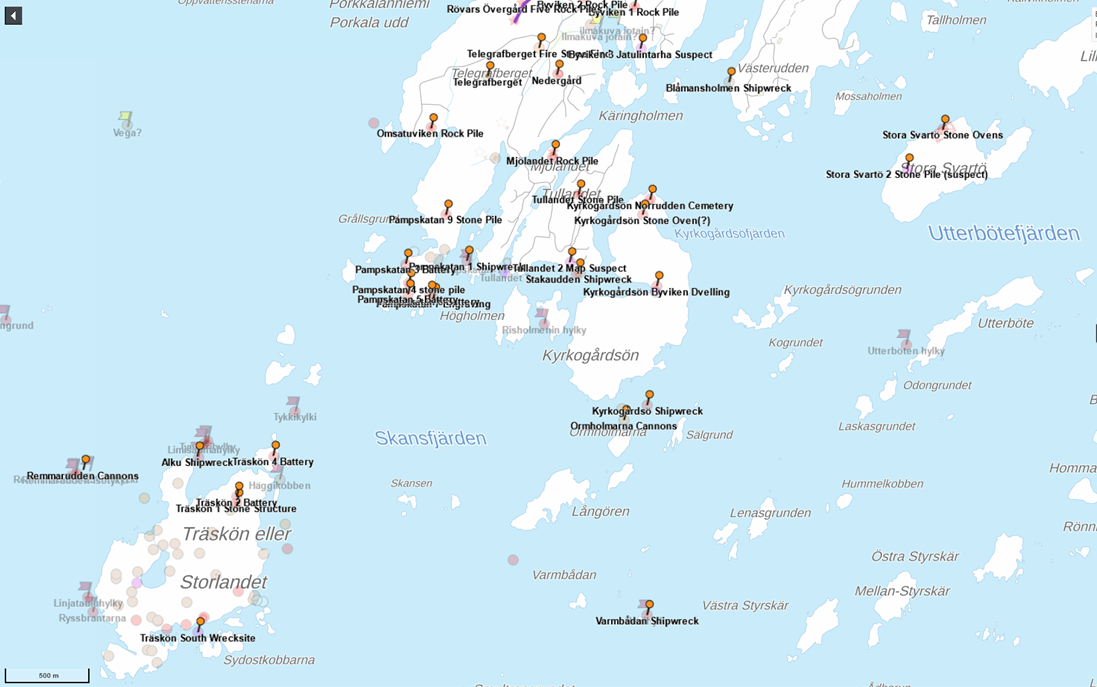
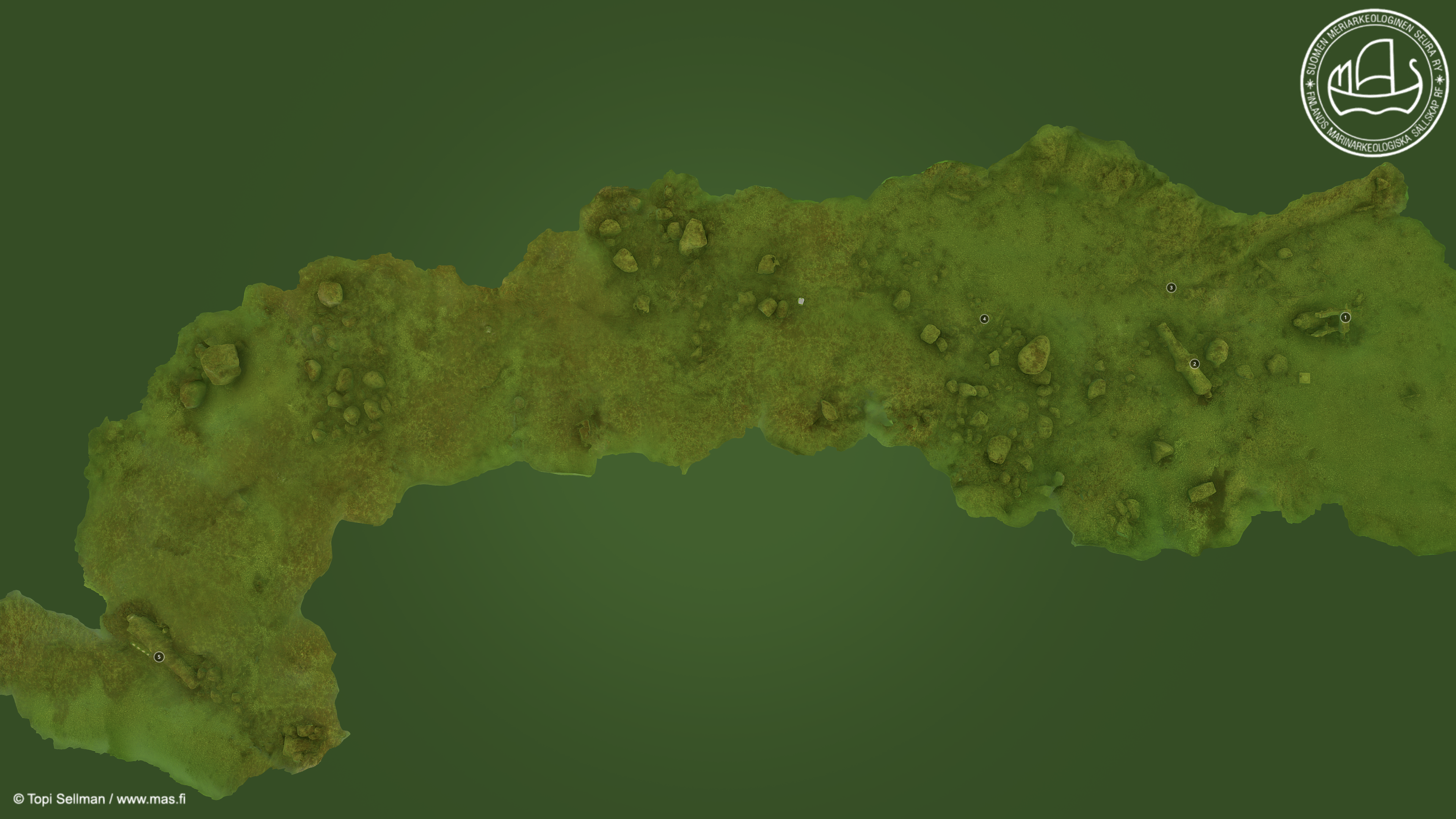
Interactive Site Map of Porkkala and Excell thereto
The potential research sites (currently identified) are displayed on the interactive map below and in this Excel. ![]() porkkala_potential_sites.xlsx
porkkala_potential_sites.xlsx
On the map below, orange pins contain English (AI) translations of the site descriptions in FHA's heritage registry. That is the same information as in the Excell above. This map/Excell is the ontology of all known and suspected archaeological sites in the Porkkala peninsula area. Hence, it's not a list of final research sites, but merely an index of the potential sites, the attendance of which depends on weather conditions, training syllabus or active research questions.
Short manual:
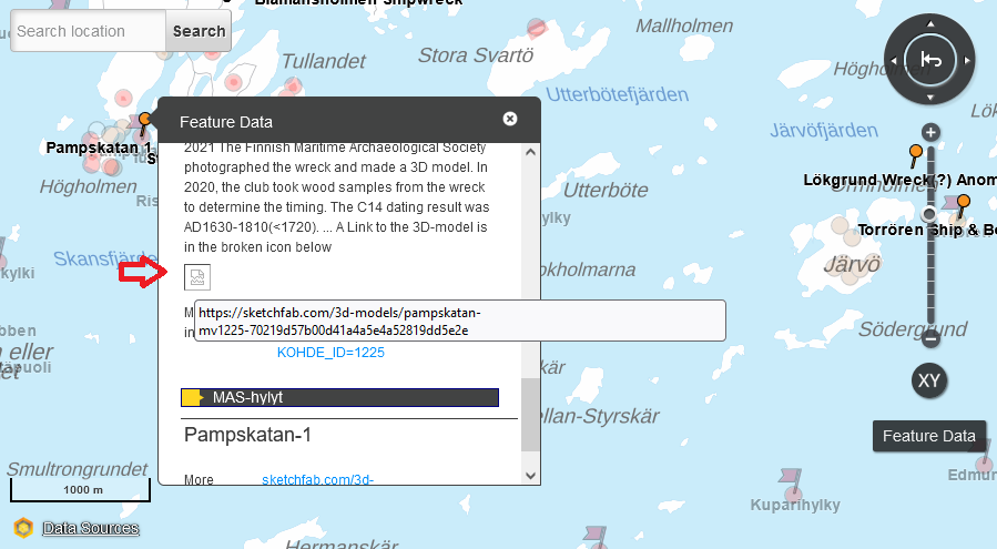 If there's a 3D-model of the wrecksite in Sketchfab.com, it can be launched by clicking the "broken" icon just below the description text (marked with red arrow in the picture on hte left). The visible link will take to the official FHA heritage site in Finnish languge only.
Topographical map window (Finland)
The topographical map window below also contains an aerial photomosaic view, which can be selected from the tools on the right hand corner of the map window.
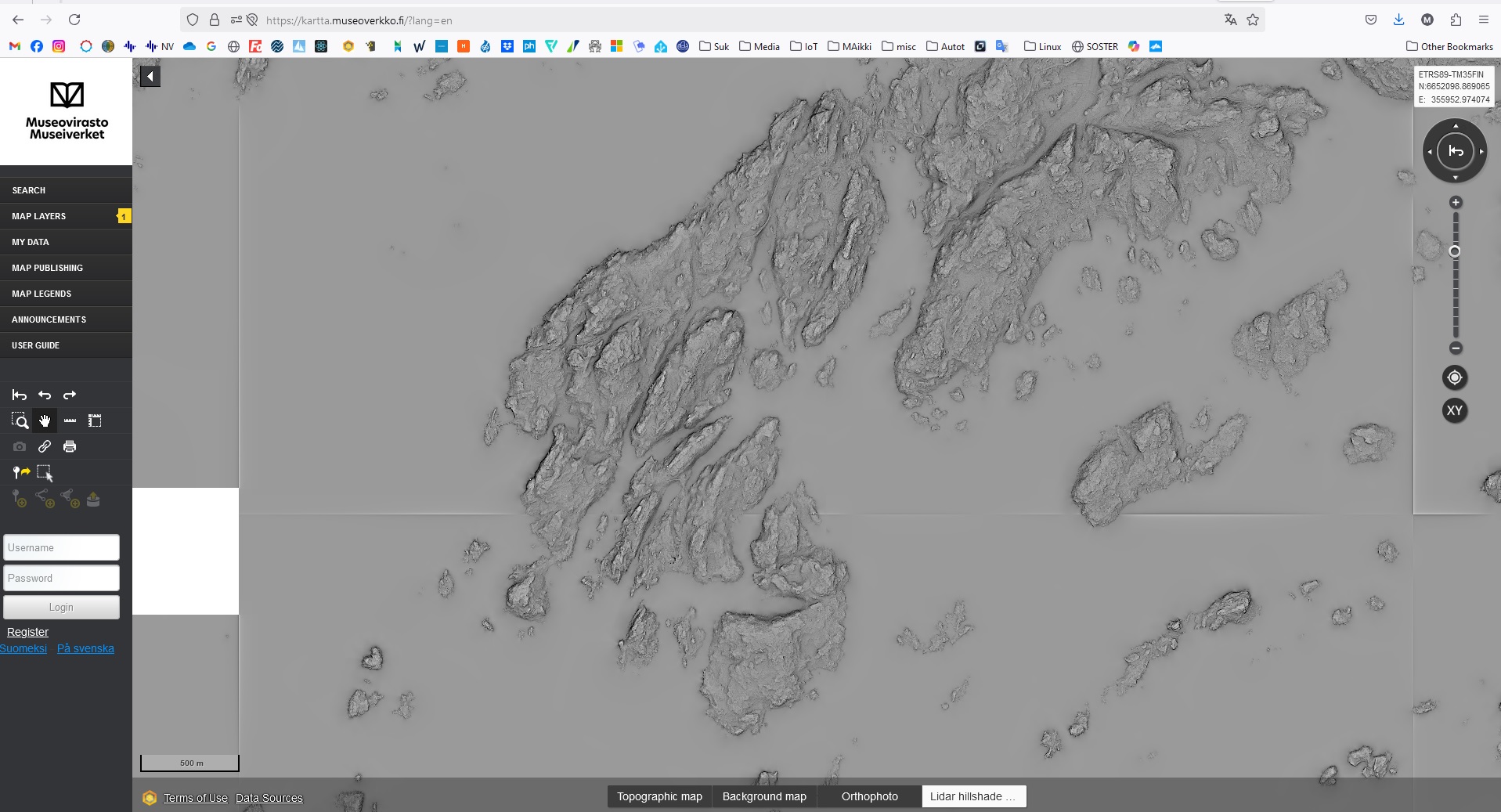
Lidar & Orthophoto & Maps tool
(click on the map to open Google map in a new window)
There's a coarse LIDAR material and an orthopohoto layer (along with base and topographical maps) available in FHA's service, which will open in a new window by clicking the picture below. Unfortunately the "orange pins" i.e. the English language annotations can not be copied to this tool => one has to use the windows side by side. The maps / orthophoto / LIDAR can be toggeld on the bottom of the window.
The MAS.Fi flagship DSV Stella's homepage
Historical context and sources

The written history of Finns is very scarce, as their language "Finnish" only became litterate through the Lutheran Reformation in the mid 16th century. The first description of Estonians, Finns and other Finnic tribes of the Baltic sea is found on the very last chapters of the "De origine et situ Germanorum" (English translation) by Publius Cornelius Tacitus, a Roman historian from the first century. Throughout the Roman period and early middle ages Finns are mentioned on maps or in various manuscritp's side notes as Fenni, Finni, Skrid Finnoi (skiing Finns) or "Suomi" - the latter which is Finland in Finnish and other Uralic languages. In the scarce references of Finns they are often placed as the furthest people in the northern Europe and their geographical connection to the rest of Europe is only vaguely known.
The later more detailled descriptions of Finns appear in the "Viking" (Norse) sagas of 8th or 9th century, in which almost all north European royal houses of the early middle age legitimate their royal status through inheritance by marrying a Finnish Princess. Even the Scandinavian demigods like Thor, Luke etc. were said to have a Finnish grandfather (Fornjót). The more formal records of Finns are found from the Papal letters of the late12th century and from the first tax - or more likely tax relief - records of the mid 13th century, when Finland joined newly established Sweden - possibly to ally against the Mongols of the "Golden Horde" ravaging the middle and northern Europe at the time.
The written records of Finns or Finland from the high middle ages remain scarce, but towards the late middle ages, document numbers reach almost 7000 (as of 2023). The best Finnish effort to collect them is the Diplomatarium Fennicum database within the Finnish national archives. This however, contains documents mostly from the nearby state archives like those of Sweden and Estonia. Almost certainly there are yet to by identified documents of Finns and Finland in the city/national archives of the Finnish trading partners ports of call or origin.
The Swedish colonial period from mid 13th century untill the early 19th century (-1809) is still being debated, as to how colonized Finland really was or not. Consensus has so far been reached only about the beginning of the colonial period from about mid 13th century. The present scholars agree that Finland was never concured by crusaders, as an old Swedish tale may suggest, but instead became colonized by its own right - possibly seeking military support against the Mongols of the Golden Horde, who beat the Teutonic Knightshttp://en.wikipedia.org/wiki/Teutonic_Order and other European great armies at the time.
The Imperial Russian colonial period is called the "autonomous period" in Finnish history, as Finland was granted a separate and highly autonomous status as a Grand Duchy of Finland, where the Russian czar was also the head of state of Finland, but with a separate title of Grand Duke of Finland. This period saw the birth of Finnish national institutions from public schools to various government offices, its own money "Markka" in use till 2002, own postal system with stamps and even its own flag albeit unofficial. Probably the most important development was however the academic freedom and accreditation of the Finnish language, which sparked a very strong nationalistic movement in terms of collecting all forms of cultural heritage around Finland and other Finnic tribes, which is probably the largest such collection ever acquired. Finnish national epic "Kalevala" was based on just a tiny fraction of the collected material, but nevertheless it became a globally known phenomena and had heavy influence in epical prose like "The Lord of the Rings", where Finns inspired the Hobbits.
Finland gained its independence through World War One and Russian revolution(s), followed by a short but bloody civil war between the socialist "reds" and conservative "whites" who prevailled. After the civil war Finland quickly established itself as one of the most democratic republic states in the world by granting an unilimited voting rights to all its adult citizens. Finland's constitution established in 1919 was said to be the closest thing to U.S. Constitution at the time. Hence untill joining the EU, Finnish president had a very influental role in domestic policies as well. Today the Finnish president leads Finland's foreign policy.
The Second World War was a tough time and a test of national unity for the Finns. Soviet Union (Russia) made an agreement with German Nazis about splitting Europe between them and Finland was to be Russia's. Thus, they attacked Finland in the prelude of the WW2 in 1939. To everyone's surprise, Finns stood their ground aided by the very hars weather, hence the name "Winter War (of 1939)". It was said to have been so cold, that even whiskey froze over in a glass. By the next spring, Finland agreed to an armistice with Russia - more or less along the current border line. In June 1941 Finnish Government made a grave mistake by siding with the Germans in their attack to Soviet Union to regain the lost "Karelia", despite a warning delivered by a "remarkable U.S. statesman". Hence a "Continuation War" ensued, with initial success for the Finns, as they regained their lost territories, but resulting a retreat to the same border line as before. Finns lost more warriors per capita than any other nation taking part in WW2, but Finns also had the least civillian casualties per capita. In the end, there were only three capital cities never concoured in the WW2: Washington, London and Helsinki.
During the Cold War Finland was in a similar position with the Soviet Union that Canada was with USA - albeit back then the U.S. presidents had dignity not to abuse the relationship. In the very end of the Cold War period, some populistic politicians used the Soviet relationship to advance their personal carreers, hence the term "Finlandization", which was only true to the "WOKE" minority of the time. Practically the Cold War started to end in Finland after the "Praque Spring" in 1968, when it became evident for the Finns, that Soviet Union could not muster Warsav pact forces against Finland and if they would attack by Russian forces alone, they'd probably loose all eastern European countries, which where just waiting for the right moment.
The end of the Soviet Union was a commercial disaster for the Finns, because the bilateral trade had been very profitable for the Finns. Luckily the emergence of mobile phones (Nokia) and ITC sector lifted Finland among the highest ranking Scandinavian economies in the 1990's where it prevailled until the global banking crises of 2007/2008. Thereafter the Finnish economy has stagnated and the effects of reversed age pyramid, socialist goverments etc. have taken their toll. However, Finns have been elected as the happiest people on the Earth for 7 years in a row now 
Regarding foreign trade outside the Baltic Sea during the age of sail, the Danish Sound Toll Registrys are a signifficant source from 1477 AD onwards. The Lloyds' Register is also a very valuable source from 1764 onwards. Naturally the large language model artificial intelligence services like Chat-GPT and Copilot are excellent search tools for many things, but they still have a lot of issues "understanding" the "exlusive or" of the things past.
Links to geographically linked histories
- History of Finland: https://en.wikipedia.org/wiki/History_of_Finland
- Viking voyages to Bjarmia: https://en.wikipedia.org/wiki/Bjarmaland
- History of Estonia: https://en.wikipedia.org/wiki/History_of_Estonia
- Timeline of Tallinn: https://en.wikipedia.org/wiki/Timeline_of_Tallinn
- History of Sweden: https://en.wikipedia.org/wiki/History_of_Sweden
- Driva, a Finnish princess to legitimize Swedish kingdom: https://en.wikipedia.org/wiki/Vanlandi
- History of Denmark: https://en.wikipedia.org/wiki/History_of_Denmark
- Signe, a Finnish princess to legitimize Danish kingdom: https://en.wikipedia.org/wiki/Signe_(Finnish_princess)
- History of Norway: https://en.wikipedia.org/wiki/History_of_Norway
- Snøfrid a Finnish princess to legitimize Norvegian kingdom: https://snl-no.translate.goog/Sv%C3%A5se_Finnekonge?_x_tr_sl=auto&_x_tr_tl=en&_x_tr_hl=fi&_x_tr_pto=wapp
- History of Latvia: https://en.wikipedia.org/wiki/History_of_Latvia
- History of Lithuania: https://en.wikipedia.org/wiki/History_of_Lithuania
- History of Russia: https://en.wikipedia.org/wiki/History_of_Russia
and just in case: https://en.wikipedia.org/wiki/History_of_Europe
Links to other relevant histories
- Danish king Valdemar's sailing route description from the AD 1230's: ![]() itinerarium_marinum_balticum_regis_danorum_valdemari.pdf
itinerarium_marinum_balticum_regis_danorum_valdemari.pdf
- Teutonic order: https://en.wikipedia.org/wiki/Teutonic_Order
- Republic of Novgorod: https://en.wikipedia.org/wiki/Novgorod_Republic
- Alexander Nevski: https://en.wikipedia.org/wiki/Battle_on_the_Ice
- Black Death plaque: https://en.wikipedia.org/wiki/Black_Death
- Victual Brothers - the Pirates of the Baltic Sea: https://en.wikipedia.org/wiki/Victual_Brothers
- Soviet ruins in Porkkala: https://www.lynx.fi/parenteesi-suunnistuskartalle/
Gulf of Finland, Camp Porkkala and other potential places visited during the The Field School
(click on the map to open Google map in a new window)
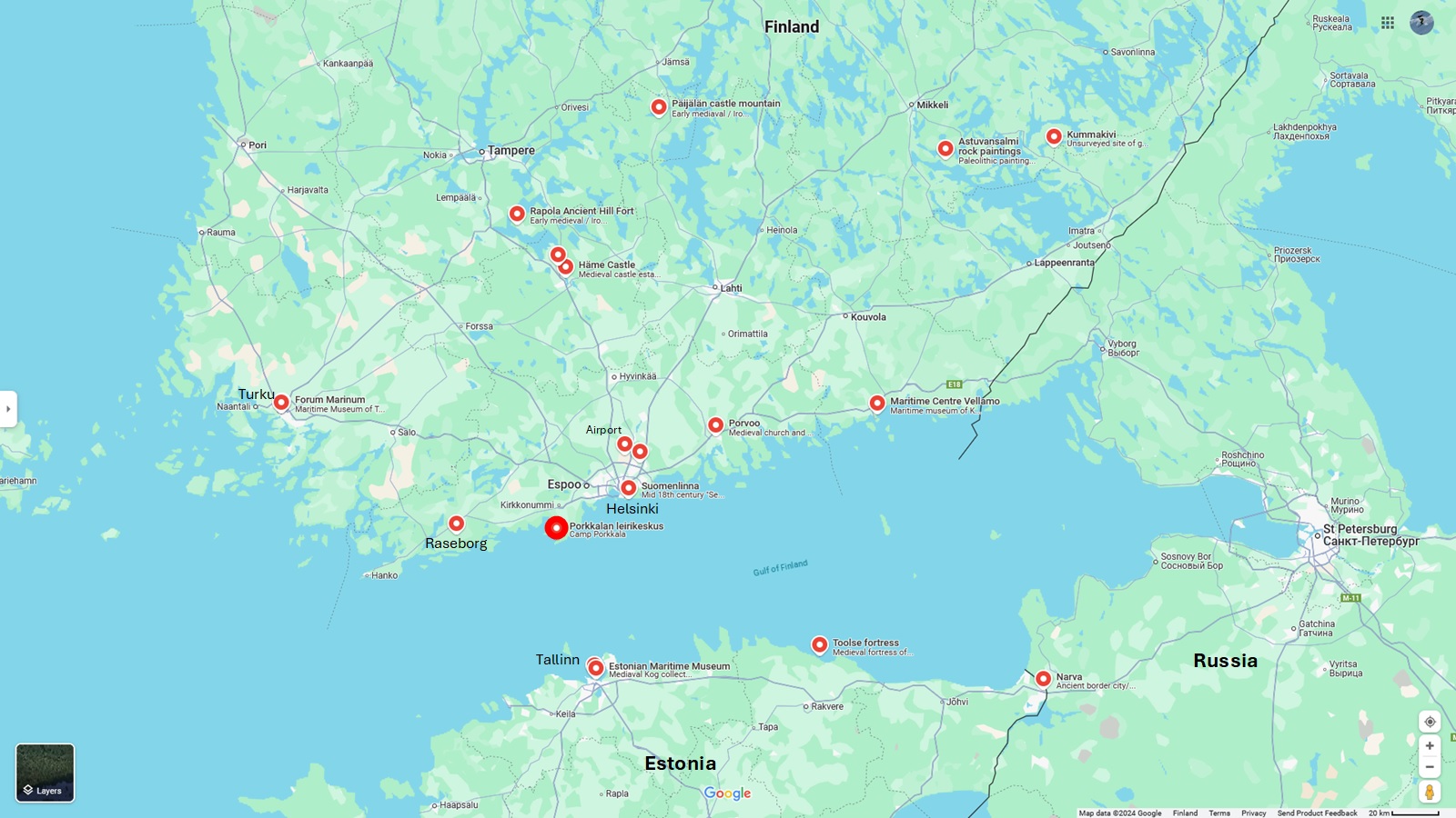
Legend
Finland:
- Porkkalan Leirikeskus = Camp Porkkala, the base camp of the Field School
- Airport = The Helsinki-Vantaa airport where ECU team will arrive/depart
- Suomenlinna = The 18th century sea fortress where the second weekend of the Field School will take place
- Forum Marinum = Maritime Museum of Turku. Primarily displaying 20th century ships of the Finnish Navy.
- Turku Castle = Mediaval fortress but completely rebuilt after WW2
- Häme Castle = Medieval castle established by the Swedish colonialisation
- Holy Cross Church = One of the oldest mediaval churches in Finland
- Rapola Ancient Hill Fort = Early medieval / Iron Age stronghold of Finns - the largest of it's era in the whole of Europe
- Päijälän Castle Mountain = Early mediaval / Iron Age stronghold which has seen battle around 1100 AD. Very typical of it's kind (over 200 in Finland)
- Astuvansalmi rock paintings = Paleolithic paintings from 3000 BC including extremely rare female hunter figures
- Kummakivi = Unsurveyed site of gigantic balanced rock, rumoured to be an ancient court of justice
- Maritime Center Vellamo = Maritime museum of Kotka, Primarily focusing on 20th century civillian sea faring. Some archaeology too.
- Porvoo = Medieval church and early medieval stronghold + a nice 19th century old town
- Husholmen Medieval Fortress Island = A middle aged stronghold associated with Victual Brothers pirates near Porvoo
- Museoviraston kokoelma- ja konservointikeskus = Finnish Heritage Agency collection and conservation center
- Raseborg Castle Ruins = Medieval fortress of potentially Teutonic origin.
Estonia:
- Tallinn = A 13th century "Hansestadt" - probably the best preserved in Europe - especially the old town.
- Estonian Maritime Museum = The home of most Kogs found
- Toolse fortress = Ruins of a 14th century castle of the Teutonic Knights and northern most fortress of the Holy Roman Empire
- Narva = A medieval (twin) bordertown of one of the oldest cultural, language, religious and tribal as well as state borders in Europe
- Lennusadam = Former "Air Harbour" and a maritime museum of mostly 20th century sea faring
Latest update: 20th of Januaty 2025


Lisää uusi kommentti